Pelister National Park Guide: Peaks, Molika Forests, Lakes, and Mountain Trails in North Macedonia
Pelister National Park gives North Macedonia one of its clearest mountain identities. It rises above Bitola on the Baba massif and brings together high peaks, old pine forests, glacial lakes, stone fields, and long views across Pelagonia and Prespa. The park’s official site says Pelister was proclaimed on November 30, 1948, and covers 17,150 hectares. That makes it the country’s oldest national park by the park authority’s own dating. The park also centers on a mountain world that climbs to 2,601 meters at Pelister peak, which gives the whole area its shape, climate, and strong sense of scale.
What makes Pelister so rewarding for visitors is the way it teaches the landscape step by step. You do not need mountaineering experience to understand why this place matters. The lower sections introduce you to forest and cool air. The middle section opens views and marked trails. The higher section brings rock, sky, cirques, and the famous lakes known as Pelister’s Eyes. North Macedonia Timeless places the park between the Prespa Valley and the Pelagonia Valley on the northern slope of Baba Mountain, and that location helps explain why so much opens out from one mountain range. You stand in one park and read a large part of southwestern North Macedonia at once.
Why Pelister Holds a Special Place in North Macedonia
Pelister matters first because of its age and protection history. The park authority says it was proclaimed in 1948, while tourism material from North Macedonia Timeless calls it the first declared national park in the country. Either way, the core fact stays clear. Pelister entered protected status early and has held that role for decades because its natural value stood out on a national level. The official park material also ties that protection to the Baba massif and to the need to preserve a large mountain ecosystem rather than a single peak or lake. That gives the park a broader meaning. Pelister is not just a scenic summit. It is a protected mountain system with forests, water, wildlife, and trails that all connect.
Its identity also comes from geography. North Macedonia Timeless describes Baba as the southern mountain on the Balkans with alpine characteristics, and that phrase helps first-time visitors understand the park quickly. Pelister feels different from lower hills and gentler countryside because it carries a true high-mountain profile. The ground changes fast as you climb. Forest gives way to stone, grass, and open ridges. Views widen. Weather shifts. The park’s elevation range runs from under 1,000 meters to 2,601 meters, which creates strong contrasts in a relatively compact area. That vertical range is one reason the park feels rich and varied even on a short visit.
The Baba Massif Shapes Everything You See
The Baba massif gives Pelister its backbone. The mountain does not serve as a background feature. It drives the whole experience. It places the park between major valleys, directs the views, and creates the conditions for the forests and glacial forms that visitors come to see. North Macedonia Timeless notes that from Pelister the view reaches toward Prespa Lake, Galichica, Jablanica, the Pelagonia plain, and the city of Bitola. That wide horizon explains why even a half-day visit can feel full. A short climb already gives a strong visual reward, while a longer route gives a far deeper sense of mountain space.
The geology adds another layer that visitors often feel before they name it. North Macedonia Timeless describes Pelister as a horst, and the official park and tourism material both point to stone rivers, sharp rocky forms, and glacial traces as key features of the terrain. In plain terms, Pelister looks rugged because the mountain really is rugged. Granite, broken rock, cirques, and long stony stretches shape the eye at every level. That is why the park feels both educational and dramatic. You are not looking at an ordinary woodland outing. You are walking through a mountain with a strong geological character that shows itself clearly on the trail.
Molika Forests Give Pelister Its Signature Character
If one natural feature defines Pelister, it is the Molika pine. The official park flora page calls Pinus peuce a Balkan endemic and a tertiary relic, while North Macedonia Timeless describes it as the species that gave Pelister a large share of its scientific and protective value. The tourism page also says Pelister has Molika trees older than 230 years. That matters because these forests do more than add greenery. They give the park its identity. When people picture Pelister, they often picture the cool, straight, high-altitude stands of Molika climbing across the slopes.
The educational value of those forests is easy to grasp on the ground. North Macedonia Timeless says Pelister hosts about 88 woody plant species in 23 families, which is a striking share of the country’s dendroflora. Yet Molika still stands at the center of the story because it combines beauty, rarity, and place. The same source notes that the German botanist August Grisebach described it scientifically in 1839. That detail helps visitors see Pelister as both a travel destination and a field site of real botanical importance. Even a simple forest walk here carries that background. You walk among trees that helped justify the park’s creation in the first place.
The Lakes, Viewpoints, and Summit Routes Define the Classic Pelister Experience
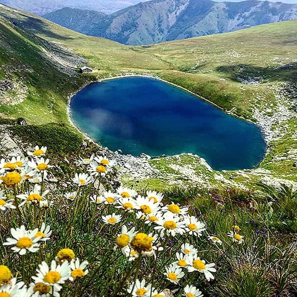
The two glacial lakes known as Pelister’s Eyes sit at the heart of the classic Pelister image. North Macedonia Timeless says the Big Lake and the Small Lake lie about two kilometers apart, and the park’s official trail pages build several routes around them. One official trail description gives a six-kilometer route from Nižepole to Big Lake with a walking time of about three to three and a half hours. Another route links Big Lake, Small Lake, and Pelister peak in a trail section of 6.5 kilometers that takes about two to two and a half hours. These details matter because they show how the park’s headline sights connect in a real hiking structure rather than in isolated postcard views.
The lakes work so well because they change the mood of the mountain. Forested lower slopes feel enclosed and quiet. The glacial basins feel open, high, and spare. Water brings color and calm into a harsher alpine setting. North Macedonia Timeless also notes that endemic trout live in these lakes, which adds ecological depth to their visual appeal. When hikers reach the lakes, they do not just reach a pretty stopping point. They reach one of the park’s defining mountain ecosystems. That shift in scenery gives a full-day Pelister route its natural rhythm. You climb through forest, break into the open, meet the lakes, and then decide whether to rest or push on toward the summit.
Viewpoints also play a big role in shorter visits. The official rocky trail from Hotel Molika runs for about eight kilometers and takes roughly four and a half to five hours, passing through Kopanki and up through the stones to a viewpoint. That route captures the character of Pelister very well. It starts from a practical mountain base, moves through forest, and then opens onto the rougher upper terrain that gives the park its strong visual drama. For visitors with limited time, that kind of trail works especially well because it brings together the park’s key elements in one compact day.
Pelister Also Carries the Memory of War
Pelister holds natural beauty, yet it also carries historical weight. North Macedonia Timeless lists a historic trail linked to the First World War, and the official park site has a dedicated Historical Trail that explains the war events that took place on Baba Mountain and Pelister during that period. The park also maintains a permanent World War I exhibition and describes the trail as part of that broader historical interpretation. That gives visitors a different way to read the mountain. Pelister is not only a place of forests and lakes. It is also a place where twentieth-century conflict left marks on the landscape.
This historical layer adds depth to a hike because it changes what you notice. Trenches, old positions, and wartime routes remind you that mountains serve more than one role. They offer refuge, beauty, and recreation, yet they also become strategic ground in times of war. On Pelister, the historic trail gives that memory a clear place within the visitor experience instead of leaving it hidden. For travelers who want more than scenery, this part of the park adds substance. It connects the mountain to the history of the wider Bitola region and to the old Macedonian Front of the First World War.
Pelister Changes with the Seasons
Pelister works across the year because each season pulls out a different side of the park. In warmer months, hiking and flora walks make the strongest case. North Macedonia Timeless calls the climate favorable and gives an average July temperature of 18.4°C, which helps explain why summer hiking here feels fresh compared with the heat of the lower valleys. Spring and early summer also suit visitors who want to see the diversity of the mountain vegetation and walk longer routes without the full harshness of high summer sun in the lowlands.
Winter brings a different rhythm. Hotel Molika describes the winter tourist season as dependent on weather and lasting around four months, and the hotel notes that the ski center sits about 100 meters below the property. Its own materials also describe lifts at Kopanki and position the hotel as a direct base inside the park at Begova Česhma. That makes Pelister practical for travelers who want a mountain stay with direct access to winter sports and cold-season walking. Instead of presenting one fixed season, Pelister gives you a mountain that changes character and keeps offering reasons to return.
How to Plan a Visit Well
Pelister can work as a short scenic escape, a full hiking day, or a mountain weekend. North Macedonia Timeless says Bitola lies about 15 kilometers from the Kopanki locality, which helps explain why the park fits easily into a city-based stay. Hotel Molika also serves as a clear base point for visitors who want accommodation inside the park area, and the official park materials direct hikers to the website and Info Centre for maps, brochures, and trail information. In practical terms, that means you can build your visit around your energy level. A short outing can focus on forest, a viewpoint, and lunch. A longer day can aim for the lakes or the summit.
Current visitor rules deserve a quick check before you go. In a June 2025 notice, Pelister National Park said that visitors who plan to stay in the park need an entry permit in advance. That notice speaks specifically about staying in the park, so it is wise to check current guidance through the park’s channels or Info Centre before an overnight visit. This matters more than chasing old travel tips. Mountain weather, trail access, and permit rules shape the day far more than any generic itinerary can. Pelister rewards simple planning, proper layers, and enough time to slow down.
Why Pelister Deserves a Place on Your Itinerary
Pelister deserves a place on any North Macedonia itinerary because it shows the country’s mountain character in a clear and satisfying way. The park gives you altitude, rare forest, glacial water, open views, and a real sense of protected landscape. It also gives structure. You can understand it through the Molika forests, through the lakes, through the summit, or through the wartime history trail, and each route still leads back to the same core idea. Pelister is a mountain park with depth. It rewards curiosity as much as fitness.
In the end, Pelister feels memorable because the mountain keeps changing as you move through it. The lower slopes invite you in. The forests cool the pace. The rocky upper sections sharpen the view. The lakes soften it again. Then the horizon opens across valleys and distant ranges. That sequence gives the park its power. Pelister does not rely on one famous photo spot. It builds its effect mile by mile, which is exactly why it stays with people long after the walk ends.
Tours that include this place
Bitola Pelister Heritage

Half-day blend of Bitola’s monuments and Pelister nature: Clock Tower, bazaars, St. Demetrius, Heraclea mosaics, then forest drive to Hotel Molika and Big Rocks lookout. Culture, air, and views.
Pelister Villages Explorer

City-to-mountain loop: Bitola landmarks and Heraclea, Rotino lake picnic, Molika lunch in Pelister pines, then Malovište’s stone roofs and 13th-century church. Heritage, serenity, and village life.
Pelister Galichica Panorama

Two-park panorama: Bitola highlights, Rotino and Molika, Malovište’s chapel, then Galichica ridge with sweeping views of Lakes Ohrid and Prespa. Culture, mountain lunch, and epic photography.
Pelister Loutraki Retreat

Active wellness day: Pelister pine hike with Hotel Molika coffee, Florina flavors, then Loutraki thermal pools set in forested hills. Ten indulgent hours balancing altitude, cuisine, and spa time.