Galichica National Park Guide: Mountain Views and the Ridge Between Ohrid and Prespa
Galichica National Park gives North Macedonia one of its clearest mountain experiences. The park rises between Lake Ohrid and Lake Prespa and forms a long limestone barrier that separates two of the country’s defining landscapes. The park’s own information page says North Macedonia declared Galichica a national park in 1958 in order to preserve its plant life, animal life, and natural appearance. The same page says the park covers about 24,000 hectares, while the official site statistics list 24,151 hectares. That combination of protection, scale, and position explains why Galichica matters so much. It is a high mountain park with rare biodiversity, strong visual drama, and a setting that visitors understand right away.
The geography gives the park its first big advantage. Galichica stands in the southwestern part of North Macedonia on the Galichica massif, with open exposure toward Ohrid on one side and Prespa on the other. The park’s official page places its altitude from 695 meters at Lake Ohrid and 850 meters at Lake Prespa up to 2,265 meters on the border ridge, while Magaro reaches 2,254 meters and dominates the park’s interior skyline. That vertical rise creates the kind of mountain space that changes fast as you move through it. Lower areas feel close to the lakes and villages. Higher sections open into exposed ridges, karst fields, high pastures, and broad views that stretch across both basins.
Why Galichica Feels Different from Other Parks
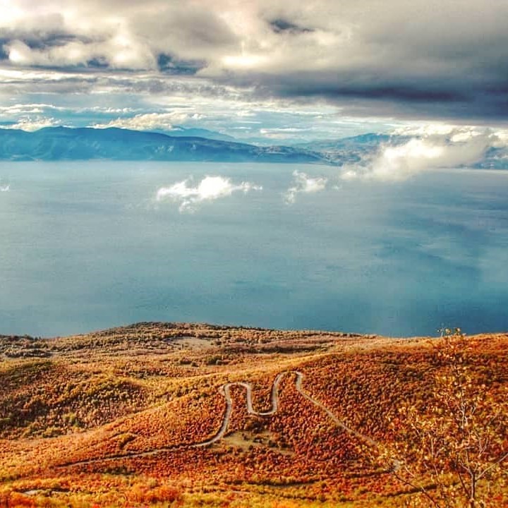
Galichica feels different because it sits between water and height at the same time. A visitor can drive or hike upward from the Ohrid side and suddenly see both lakes in a single sweep. North Macedonia Timeless describes that double-lake view as one of the park’s defining attractions, and the official park site builds its visitor offer around peaks, lookouts, trails, and platforms that make that geography easy to experience. This gives Galichica a rare kind of clarity. A traveler does not need deep hiking knowledge to understand the place. The mountain itself explains its value through the way it frames the region.
The geology adds a second layer to that appeal. The park’s official information page says Galichica rests on a base of older metamorphic rocks covered by a thick layer of porous limestone. Because of that porous limestone, Prespa and Ohrid connect underground through the mountain mass. The same source points to the springs near St Naum as one of the clearest expressions of that karst system. This matters because Galichica is not only scenic. It also teaches visitors how landscape works. The rock under your feet shapes the water, the plants, the caves, and the character of the whole mountain.
A Park Built on Biodiversity
Galichica earned protection for a reason, and that reason begins with biodiversity. The park’s official page calls it a hotspot of biological diversity on a regional and wider global scale. It says the park holds more than 37 habitat types, 40 plant communities, around 1,600 taxa of vascular plants, more than 143 species of lichenoid fungi, more than 480 fungi species, and over 3,279 fauna taxa on a relatively small territory. It also says several hundred rare and protected species live here in significant populations, and some occur only within the park’s boundaries. That level of richness gives Galichica scientific weight as well as travel appeal.
North Macedonia Timeless supports that picture from a visitor angle. Its Galichica page says the park contains over 600 floristic species and over 170 species of woody vegetation, while the park’s own statistics page highlights 1,644 butterflies. The official flora and fauna catalogue also lists well-known species such as the Apollo butterfly, swallowtail, yellow-billed chough, Balkan lynx, chamois, brown bear, and several reptiles and amphibians. When travelers walk the ridges or mountain meadows, they move through a living system rather than a simple viewpoint road. The beauty comes from that ecological depth. Flowers, insects, birds, and rocky grasslands all belong to the same mountain story.
This biological variety also helps explain why the park changes so much from one slope to another. Steep rocks, talus fields, shallow soils, deeper pockets of earth, and open alpine ground create different niches across a small area. North Macedonia Timeless says that Galichica’s relief and environmental conditions produced plant forms that are rare or characteristic only for this space. For visitors, that means the park rewards slow attention. A ridge drive gives huge views, yet a short walk can reveal orchids, alpine flowers, butterflies, and grasses that make the mountain feel just as rich at ground level.
Magaro Peak Gives the Park Its Classic View
Magaro stands at the heart of the classic Galichica experience. The official park information page lists Magaro at 2,254 meters, and North Macedonia Timeless describes it as the peak from which both Lake Ohrid and Lake Prespa spread out at once under favorable weather. That single fact makes Magaro one of the park’s signature goals. Travelers climb it for the same reason photographers and nature lovers return to the ridge again and again. The summit gives a visual summary of the whole region. You see the mountain as a divider, the lakes as paired bodies of water, and the valleys opening beyond them.
The official trail pages show how central Magaro is to the park. The park lists a dedicated “Galicica Pass to Magaro Peak” route and also groups several heavier ridge trails around the higher parts of the massif. North Macedonia Timeless adds that the route toward Magaro passes two cirques from the last ice age and crosses rich high-mountain pastures on the way. That makes the hike more than a summit push. It becomes a compact lesson in glacial landforms, karst terrain, alpine ecology, and regional geography. Each section of the climb adds another piece to the picture.
The Ridge Road Makes Galichica Easy to Understand
Galichica also works well for travelers who want a strong mountain experience without a full summit day. The official site lists the regional asphalt road P-504 as part of the “Galicica Pass to Magaro Peak” route and uses the pass as a key access point for several suggested trails. That road matters because it opens the ridge to short scenic outings, not only to dedicated hikers. A drive to the pass already gives a dramatic change in perspective. You leave the lake edge behind, gain height quickly, and enter a dry, open mountain world where the horizon broadens in every direction.
This kind of access makes Galichica unusually flexible. A short visit can focus on the pass, a few photo stops, and one gentle walk. A longer day can include Magaro or a traverse between villages and ridges. The official trail list shows routes that link Ramne, Velestovo, Elshani, Peshtani, Oteshevo, Goga, and other points across the park. That network lets visitors shape the day around energy, weather, and interest. Galichica does not force one single experience. It offers a ridge drive, a half-day walk, or a full hiking day with equal logic.
Activities That Bring the Mountain to Life
Hiking leads the way in Galichica, yet it is only one part of the park’s appeal. North Macedonia Timeless says the mountain slopes provide excellent terrain for mountaineering, and its recreational section also highlights views from Baba crest, Lako Signoj, Gola Buka, and Elen Vrv. The official site supports that active profile with trail categories for lighter walks, longer hikes, and heavier ridge routes above 1,600 meters. This structure helps first-time visitors choose wisely. You can start with the pass and a shorter walk, then build toward the higher ground once you understand the park’s terrain.
Paragliding gives the park a very different rhythm. The official paragliding page lists launch platforms at Baba and Pogled, while North Macedonia Timeless describes Galichica as a popular destination for paragliders and says the activity offers the rare view of both lakes at once. This makes perfect sense in a park shaped by open slopes and dramatic drop-offs toward the lake basins. From the ground, Galichica already feels expansive. From the air, that same landscape becomes even easier to read. The mountain ridge, the water, the forests, and the villages all line up in one wide frame.
Cycling and cave visits broaden the offer further. North Macedonia Timeless describes the MTB trail as suitable for both newer and more experienced riders and says the route combines views of Lake Ohrid with grassy mountain plateau sections. The same source also highlights Samotska Dupka as the park’s largest cave and says visitors can enter it with a guide from the park after prior notice. These options matter because they show Galichica as more than a lookout mountain. It is a layered park where movement, geology, and interpretation work together.
How to Plan a Visit Well
A good visit to Galichica starts with simple choices. Decide first whether you want a scenic ridge outing or a real mountain hike. The official park trail pages group routes by difficulty and list suggestions that connect the pass with Magaro, Elshani with Lako Signoj and the pass, and Oteshevo with Goga and the Sharbojca mountain house. Those route categories help you match the day to your pace instead of guessing on arrival. For a scenic day, the pass and nearby viewpoints work well. For a fuller mountain day, Magaro gives the clearest reward.
Ticket planning also helps. The park’s official ticket page lists a general ticket at 100 denars, a “Stara Galicica Peak Magaro” entrance at 300 denars, and a single entry ticket to a paragliding launch location at 300 denars. Since ticket names and product options can change, the safest approach is to check the park’s current ticket page before you go. The official site also provides the Ohrid info center contact and emergency numbers, which is useful for travelers planning longer walks or higher routes.
Season and weather deserve respect here. Galichica climbs fast from the lakes to the high ridge, and that change in altitude shapes temperature, wind, and visibility. The official park pages emphasize the mountain rescue number and classify several trails as heavier ridge routes, which signals that the higher sections call for proper planning. Good shoes, water, layers, and an early start make the day smoother and safer. The reward for that care comes quickly once the ridge opens and the two lakes appear together below you.
Why Galichica Deserves a Place on Your Itinerary
Galichica deserves a place on any Ohrid or Prespa itinerary because it explains the whole region from above. The park brings together geology, biodiversity, high pastures, summit hiking, village connections, and one of the strongest panoramic settings in North Macedonia. It also holds cultural weight. The official park page notes that around two thirds of the park fall within the World Natural and Cultural Heritage boundaries of the Ohrid region, and it lists sites such as St Naum, St Bogorodica Zahumska, and Golem Grad among its important heritage points. That means a visit to Galichica enriches both the natural and historical sides of the trip.
In the end, Galichica works because every part of it connects. The porous limestone links Prespa and Ohrid underground. The ridge links the two lake basins in one visual line. The trails link villages, passes, peaks, and meadows. The protected habitats link science and travel in a way that feels easy to grasp even for first-time visitors. Galichica does not rely on one single landmark. The whole mountain acts as the attraction, and that gives the park a lasting kind of power. Once you stand on the ridge and see both lakes open on either side, the shape of the region becomes clear in a single glance.
Tours that include this place
Pelister Galichica Panorama

Two-park panorama: Bitola highlights, Rotino and Molika, Malovište’s chapel, then Galichica ridge with sweeping views of Lakes Ohrid and Prespa. Culture, mountain lunch, and epic photography.
Ohrid Pogradec Escape

Ohrid icons, Bay of Bones, St. Naum’s crystal springs, lunch in Albanian Pogradec, and Galichica’s balcony road. A relaxed 10h cross-border day of history and horizons.
Korça Lakes Circuit

From Ohrid to Bay of Bones and St. Naum, then Albanian Pogradec and Korça for lunch and brewery buzz; return via Galichica vistas. Lake calm meets city color in 11h.
Snake Island Feast

Hike Galichica ridges, boat to wildlife-rich Golem Grad, feast in Konjsko, visit St. Naum and Bay of Bones, then sunset in Ohrid. Seasonal 12h mountain-lake adventure.